Uwan exits PAR, may re-enter on Wednesday


A weakened severe tropical storm, Fung-wong, locally known Uwan, has exited the Philippine Area of Responsibility (PAR) but may re-enter again on Wednesday, according to the Philippine Atmospheric, Geophysical and Astronomical Services Administration (PAGASA).
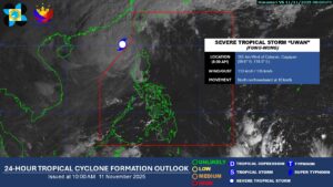
Fung-wong, packing sustained winds of 110 kilometers per hour (kph) and gusts of up to 135 kph, was last located 365 kilometers west of Calayan, Cagayan, moving north-northwestward at 10 kph, PAGASA said in its 8:00 a.m. advisory.
In an earlier advisory, PAGASA said the cyclone is expected to re-enter PAR on Wednesday as it moves toward the southwestern coast of Taiwan, where it is likely to make landfall and further weaken.
While traversing Taiwan, PAGASA said that areas in the northern part of Luzon are expected to experience gusty winds due to the typhoon’s broad circulation, particularly over Batanes and the Babuyan Islands. However, most parts of the country are no longer expected to be affected.
Fung-wong is then expected to emerge over the waters near the Ryukyu Islands, located northeast of Taiwan, and further weaken into a low-pressure area by Friday.—Edg Adrian A. Eva