Signal No. 4 still up in parts of Palawan amid Typhoon Tino


Tropical Cyclone Wind Signal No. 4 still threatens several areas in Palawan due to Typhoon Kalmaegi, locally known as Tino, which is expected to bring significantly life-threatening winds to the affected areas, according to the state weather bureau.
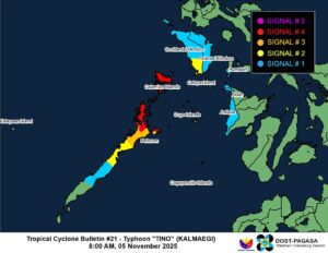
Kalmaegi was last located over the coastal waters of El Nido Palawan and has maintain its typhoon category strength despite multiple landfalls, the Philippine Atmospheric, Geophysical and Astronomical Services Administration (PAGASA) said in an 8:00 a.m. advisory.
It was packing 120 kilometers per hour (kph) of sustained winds and 165 kph gustiness, moving west northwestward at 25 kph.
Signal No. 4, where significant to severe life-threatening winds are expected, is hoisted in the northernmost portion of Palawan, covering El Nido, Taytay, Araceli, and the Calamian Islands.
Signal No. 3, where moderate to significant life-threatening winds are expected, is in effect in the northern portion of Palawan, including Dumaran, San Vicente, Roxas, and the Cuyo Islands.
Meanwhile, Signal No. 2 is placed in the southern portion of Occidental Mindoro, including Magsaysay, San Jose, Rizal, and Calintaan, as well as in Puerto Princesa City and the Kalayaan Islands, where minor to moderate life-threatening winds are expected.
Signal No. 1 is hoisted in the rest of Occidental Mindoro, Oriental Mindoro, the southern portion of Romblon, and the southern portion of Palawan, where minimal to minor life-threatening winds are expected.
PAGASA also raised storm surge warnings for various coastal areas of Palawan, particularly in the low-lying areas of El Nido, Bacuit, San Vicente, and Taytay, where storm surges of more than 3.0 meters may occur.
The bureau advised that all marine activities be canceled and that residents evacuate immediately.
Possible Super Typhoon brewing
PAGASA is considering the possibility that the tropical depression east of the Philippine Area of Responsibility (PAR) may intensify into a typhoon, or even a super typhoon, in the coming days.
The tropical depression, packing sustained winds of 55 kph and gusts of up to 70 kph, was last located 1,925 kilometers east of northeastern Mindanao, moving west-southwestward at 25 kph, PAGASA said in an 8:00 a.m. advisory.
The tropical depression is expected to enter the Philippine Area of Responsibility (PAR) by Friday evening or Saturday morning and will be locally named Uwan, becoming the country’s 21st tropical cyclone this year.
PAGASA has not yet indicated whether the storm may make landfall in the country, as it is still outside the agency’s five-day forecast period.
The weather bureau advised the public to monitor updates on the storm, as forecasts may still change given its current distance. — Edg Adrian A. Eva